UPDATED: 19/03/2021
It is quite remarkable how an accidental archaeological discovery can catapult an obscure little town onto the world stage.
The discovery in question is a map – the Madaba Mosaic Map – eponymous with the town of the same name in Jordan. Madaba was once a biblical fortress of the Moabite kingdom about which there is limited historical mention in the Bible or elsewhere.
It has been surmised, from inscriptions and statuary, that it was originally a Nabatean outpost of Petra which successively changed hands with the changing fortunes of the land.

Madaba is situated approximately a third of the way on the King’s Highway (via Regia, later renamed via Traiana Nova), an ancient thoroughfare meandering from Egypt all the way to Syria, that was once the artery of trade for the Nabateans and later the main route of pilgrimage for Christians and Muslims alike. And the control of which determined the fortunes of every empire that held sway over the region.
All that conflict as well as the commerce must surely have left a considerable impression on the settlements along the historic route. Madaba became part of Trajan’s Provincia Araba after Rome overthrew the Nabatean kingdom, reaching its monumental zenith in the Byzantine period.
But any visible signs of that prosperity remained buried under the rubble of a 746AD earthquake. A small (Arab) Christian community returned from their refuge in Kerak in the early 1880s to resurrect the town and sought permission from the Greek Orthodox Patriarchate of Jerusalem to build a place of worship.
Under Ottoman law, a Christian church could only be built on the ruins of an older church. And so a ‘firman‘ (Persian for decree) was sought from Constantinople, in 1894, to consecrate a church dedicated to Saint James* over and “in the shape and form” of an existing Byzantine church.
It wasn’t until the roof was installed and work begun on interior plaster work and paving in October 1896*, that workmen stumbled upon the hidden mosaic map beneath the debris. 6CE iconoclastic edicts (of both Islamic and Christian faiths incidentally) had robbed it of some forbidden figurative elements. The new construction and the delay in assessing its value, damaged it further.

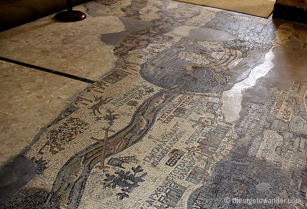
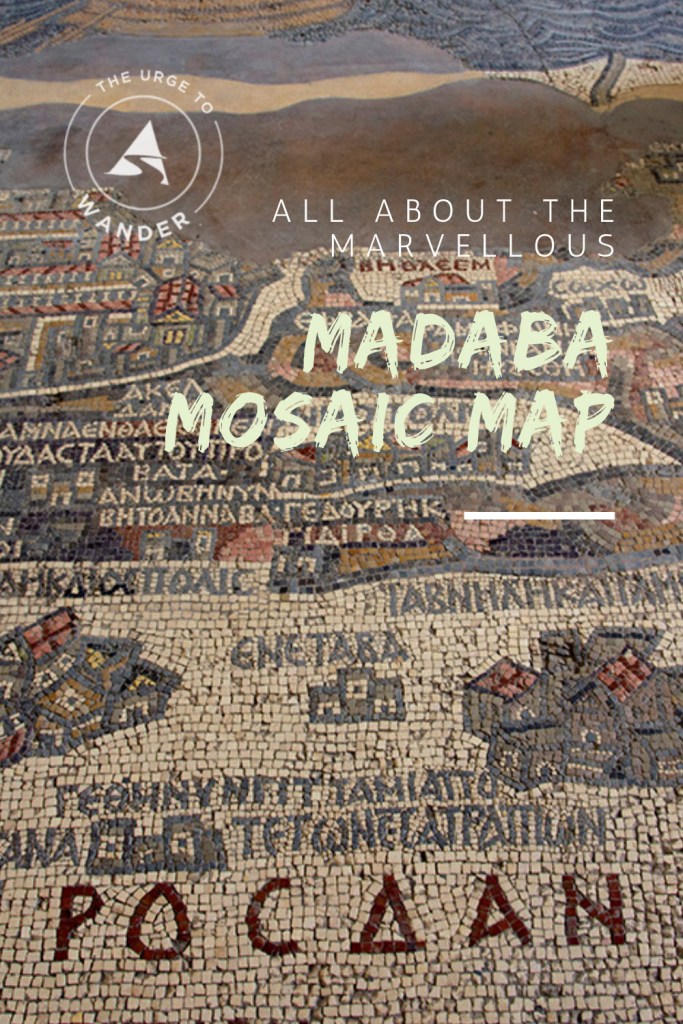
It is estimated that the original Madaba map, spanning an area of 51 ft x 19.5 ft (15.5 m x 6 m), comprised over 2.3 million coloured stone and glass cubes illustrating Biblical geography from Lebanon to the Nile delta. Only one third of the mosaic survives today. Its late 6CE/ early 7CE date is derived from the construction dates of the depicted monuments and the absence of those that came after.
While this unique cartographic representation – oriented East to West (read top to bottom) – is not to scale, it is in effect the first complete aerial view of Palestine. The intricate three dimensional details and over 150 Greek captions (referring to place names and the twelve tribes of Israel) aided in the identification of every single one of the 156 locations in the surviving fragment.

Jerusalem is depicted significantly larger and is the dominant vignette in the present space. Although it is believed that Madaba, lost forever, might very well have shared the honour in the original. The realistic portrayal of the holy walled city: the Nea Church consecrated in 527AD and the colonnaded Cardo Maximus presided over by what is clearly the holiest edifice in Christendom – the Church of the Holy Sepulchre – and flanked at both ends by two monumental gates, were key elements in the dating of the Madaba map. It remains an important source of reference for middle Eastern archaeologists.
Byzantine mosaics had been unearthed in Madaba as early as 1887. The following decades would reveal a treasure trove of hidden mosaic floors across the town. Not a single one resembled the map. The meaning and purpose of this extraordinary piece of Christian art has long puzzled scholars.
Why a map? Why in Madaba? Could it have been a pictorial guide to passing pilgrims? Or an interpretation of the vision of Moses?
Madaba’s association with Moses, the bitter conflict on his passage through these lands during the exodus, his first sighting of the Promised Land and his final moments on earth (presumed to be) at nearby Mount Nebo, all endorse the arguments for the latter and the theory of the use of the Madaba map as a visual enhancer of the religious experience.
Imagine yourself back in the 6th century at a liturgy in the Byzantine church for a moment. Then visualise the symbol of Christian salvation (Jerusalem and the Church of the Holy Sepulchre) skilfully woven into the panorama of the Promised Land in that unparalleled mosaic map beneath your feet!
DISCLAIMER: My visit & stay was sponsored by the Jordan Tourism Board.
Read Next: The history and legends of another historical monument on the Kings Highway.
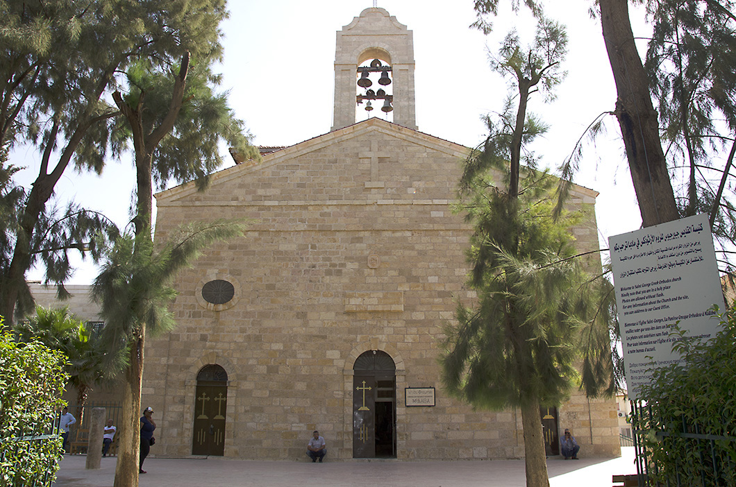
*The church was originally dedicated to Saint James. I couldn’t find details of when and why the change to Saint George took place.
*The map was unearthed in October 1986. But the official date of discovery is 13 December 1896, the day it was formally presented to a scholar for scrutiny and assessment.
LIKE IT? PIN IT!

Fascinating as usual, Madhu! I learned new things again –
classic 🙂
Great post with fantastic images – I really enjoyed it! Thank you!
Hey girl! Absolutely love your blog! Just wanted to let you know I nominated you for the One Lovely Blog Award. 🙂
Madhu writes brilliantly 🙂
Always you teach us, show us a history we sometimes forget exists in a part of the world that remains a mystery to so many of us. I fear, these marvelous pieces of art will disappear under the weight of conflict. Thank you for this one, for your writing the story and giving such wonderful visuals.
Super article. Very interesting
That was so interesting. You have such a wealth of knowledge from your many travels.
Utterly fascinating and lovely pictures, Madhu. Wish I’d visited when I was in that region in the 90s. Hope I can sometime soon…
Amazing discovery! My mum, sister and other family members on my mum’s side of the family are Catholics, as such, I grew up knowing very well of ancient history of Christianity. Reading your post is reinforcing my admiration for the historical wonders of the Middle East region, so complex and rich, and yet bemused (at the same time, not surprised) by the conflicts in that region…over religion. Thanks for sharing 🙂
I can’t tell you how long I stared at and studied these map photos! I adore maps in general; scrutinizing this one was extra fun, with decoding the Greek and its following on the heels of my trip to Israel and Jordan this summer and
Absolutely wonderful!
What an incredible history and life that flowed so long ago ~ thank you for brining it to the forefront and especially with your words and photos. How great it would be to lose yourself just looking and dreaming with that map right in front of you…
Madhu, what an amazing job you have done here … sometime I have hard to understand how they were able to build and create like they did through history. We have the most fantastic tools today .. but in that time, how were they able to measure everything up so it all fitted so well. This map is incredible. When were you in Jordan.??? Are you there now. Have a lovely weekend.
Great story! Thanks for sharing.
I love maps and I love mosaics, so this is amazing. millions of tiles – wow ❤
Old maps are fascinating, and being mosaic makes it more so. Great post.
I enjoyed your wonderful report about this place and the mosaic! I love ancient history and its art I’s a treasure we have to protect! Well done!
Such fascinating historical facts, Madhu. That map is a real work of art, and so huge. Congratulations on a wonderful an informative post.
What an extraordinary thing, Madhu! And what a shame it was so damaged.
I know. Imagine how glorious the whole map would have been!
Unbelievable! 🙂
What a story, Madhu….as ever, a great read and some excellent photographs 😊 have a great weekend!
Amazing story, Madhu. I had no idea, thanks for presenting the history behind Madaba. Great read and once again complemented with wonderful images.
Have a lovely weekend!
Thank you for reading Dina. A fabulous weekend to Klaus and you and the book fayries too! 🙂